

Hawaii Real Estate, Hawaii Homes, Hawaii Land
|
|
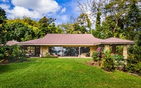
29-3794 HAWAII BELT RD, HAKALAU
© 2024 Hilo Brokers Ltd. |
|
Located on the beautiful Hamakua coast, this 3.37 acre oceanfront property is a sanctuary of nature and boasts over 750 feet of coastline, stunning ocean and coastal views, a stream with multiple waterfalls, over 60 varieties of producing fruit and nut trees, and countless ornamentals. The home is designed to complement this beautiful ecosystem and invites you to experience its loving embrace. See the property video tour: bit.ly/3U0q6pj From the home, wander down your private path with dappled s... | |
| Click Here For More Property Details |
 |
|
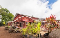
18-2464 ALA MAHINAAI, MOUNTAIN VIEW
© 2024 Hilo Brokers Ltd. |
|
Welcome home to Kilauea Anthurium Farm, a working commercial anthurium farm on 15 acres. An opportunity to live the dream of being your own boss & working from home! Please NO unauthorized visits.As you enter, the driveway is lined with majestic palms. Throughout this 15 acre estate, you'll discover a flourishing botanical haven. The collection of more than 30 unique types of anthurium, sits under 5 acres of shade cloth with an irrigation system. This allows for the harvesting of hundre... | |
| Click Here For More Property Details |
|

|
15-2649 GOVERNMENT BEACH RD, PAHOA
© 2024 Hilo Brokers Ltd. |
|
* Have you or someone you know been searching for that true oceanfront property with direct shoreline access from your own backyard? Well, have a look at this 5.27 ACRES of OCEANFRONT privacy with miles of coastline views, countless palms, wooded acreage, lawn areas and a gated, winding tree-lined driveway on the Big Island of Hawaii.* A bonus here is the included unfinished house with large ocean view windows, a covered deck and partially finished bathroom that includes stone floors and a st... | |
| Click Here For More Property Details |
|
|
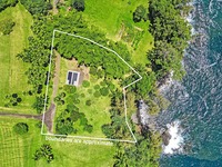
29-3792 Hawaii Belt Road, Hakalau
© 2024 Hilo Brokers Ltd. |
|
1.116 acre oceanfront Hamakua property with breathtaking views, producing orchard, ag building with septic system & county water. About 174' of ocean frontage - there is no better location to enjoy life than here, in this small private community! This property has been developed for you to complete the dream as you see fit.See the video to appreciate this lovely, rare opportunity: bit.ly/46vJ6jkFruiting trees include avocado, mango, mangosteen, lychee, grapefruit, mountain apple, ro... | |
| Click Here For More Property Details |
|
|
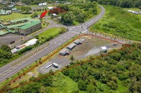
15-3070 PAHOA KAPOHO RD, PAHOA
Contingent
© 2024 Hilo Brokers Ltd. |
|
This 1.54 acre parcel was recently changed to CV-20 zoning, allowing for a long list of flexible uses and development. Potential uses include but not limited to office space, auto repair & sales, hotel, multi-family, retail, restaurants & bars, medical facility, and much more! Located at the intersection of Highways 130 and 132 at Pahoa town, this central location is within the Pahoa Regional Town Center, and Puna Community Development Plan. One of the last sites in Pahoa for large scale... | |
| Click Here For More Property Details | |

|
79-7199 MAMALAHOA HWY, HOLUALOA
© 2024 Hilo Brokers Ltd. |
|
Welcome to this beautifully renovated condo designed to bring joy and comfort to families in Hawaii. The open-concept kitchen is perfect for hosting gatherings, featuring new cement countertops, stylish bar seating, a large farmhouse sink, a convection oven, an induction cooktop, and an under-counter freezer.The lanai off the living area offers a mesmerizing peek-a-boo ocean view, ideal for relaxation. The primary bedroom opens to a fully fenced yard, creating a peaceful oasis. The recently remo... | |
| Click Here For More Property Details |
|

© 2016 Hilo Brokers LTD - All Rights Reserved


Are you looking for real estate in Hawaii? Let Hilo Brokers Ltd. help you find that unique piece of Big Island paradise. We live in Hawaii and we love the Hawaiian lifestyle. Let us share Hawaii with you.
 |